
Scotland Blairs

The Kippen Circle
My interest in Kippen stems from the fact my oldest known Blair ancestors, John Blair and Margaret McLuckie lived in Kippen in the late 1700s. Although we do not know for certain when John and Margaret were born or who their parents were, we do know the following:
1. According to the Old Parish Records of Kippen, John and Margaret were married (or posted their marriage banns) on January 15, 1749.
2. According to the Associate Session Church records John and Margaret had 8 sons and a daughter who were baptised between 1750 and 1764 in Balfron or Kippen.
3. Six of seven letters written by John to his son Robert in Barnet VT between 1786 and 1794 indicate that John and Margaret were living at Arnmore, a farm in Kippen.
4. The 7th letter written by John on May 05, 1799 came from Buchlyvie and informed Robert that his mother was buried 13 weeks ago.
5. A letter written to Robert by family friend Walter Gibbons, dated March 1800, informed Robert that his father John died in December 1799 and was buried in the Buchlyvie churchyard.
In May 2008 my wife and I returned to my "homeland" and spent 10 days in Kippen, exploring the local area and doing library and archival research. As a result of this exploration I created the "Kippen Circle".
The "Kippen Circle" is an area I define as rough circle of villages and/or parishes within an approximate 10 mile radius of Kippen, Stirlingshire, Scotland. It includes the parishes of Aberfoyle, Callander, Dunblane, and Port of Menteith in Perthshire and the parishes of Balfron, Buchanan, Campsie, Denny, Drymen, Fintry, Gargunnock, Killearn, Kilsyth, Kippen, Saint Ninians, Stirling in Stirlingshire. I consider any Blair who lived in the "Kippen Circle" to be a potential relative.
The Old Parish Records of the Church of Scotland shows almost 1,200 Blair births/christening and over 600 marriages within the Kippen Circle.
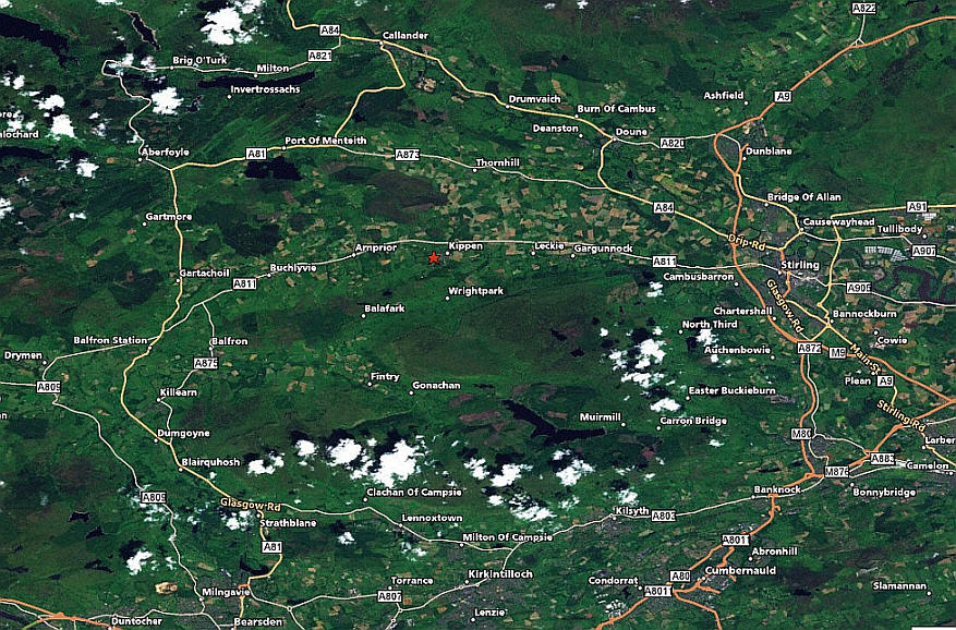
The rest of this webpage will talk about the places we stayed and the villages and sites we explored during our ten days in the "Kippen Circle". I've included a considerable number of pictures of our visit.
Larne Coachhouse: During the first seven nights in Kippen we stayed at the Larne Coachhouse. This cottage is located on Fore Road, Kippen, an easy walk to village. The official description reads "Larne Coachhouse is a comfortable, fully equipped cottage located a short walk from the centre of the picturesque and fascinating conservation village of Kippen. The cottage can accommodate 2 to 4 people and is furnished and equipped to the highest standard." Everything in the official description is totally true and if anything an understatement. Not only was the cottage evrything promised, but the landlord, Roland Howe, and his wife were extremely friendly and helpful. I would highly recommend the Larne Coachhouse to anyone visiting Kippen. For more information on the Larne Coachhouse and other cottages owned by Roland Howe, see http://www.forthcottages.com/.
Arnmore was one of eleven Baronies or properties, belonging to gentlemen entitled to call themselves Barons. There was also an Arnbeg, Arnprior, Arnfinlay, and Arnmanuel. "Arn" means a section or divison of land. As most of the lands beginning with Arn lie along the slope of the hill side and parallel or contiguous to each other, they may have been portions of a territory which was under the same superior. Arnmore was the larger portion, Arnbeg was the small portion, and Arnprior was the Prior's portion. Arnfinlay and Arnmanuel were probably portions named after individuals.
A close look an Ordinance Survey map shows Hill of Arnmore and Keir Knowe of Arnmore. Not far away is the Laird's House, also know as Arnmore House.
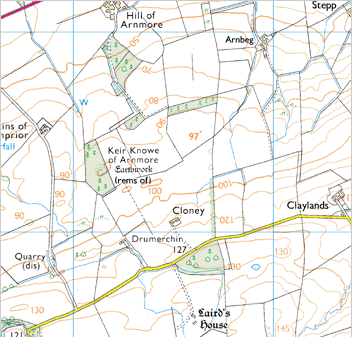
Hill of Arnmore: As I mentioned before we know that between 1786 and 1794 John and Margaret were living at Arnmore, a farm in Kippen.
Keir Knowe of Arnmore: A ditch forms the north and east sides of an enclosure which measures 50m from east to west by 30m transversely; the west end has been destroyed by a quarry and the rest of the site has been damaged by forestry ploughing. No traces of a bank can now be seen along the inner lip of the ditch or on the crest of the slope to the south. On the north side, where it is best preserved, the ditch has a maximum depth of 2'9" below the inner lip and 1' below the outer lip. The appearance of the work suggests that it is of medieval, rather than prehistoric, date. (Stirling Council: Sites and Monuments Record)
Arnmore House: This is the ruin of a small, symmetrically planned, laird's house dating from the turn of the 17th and 18th centuries. The building is a simple rectangular block lying approximately east and west. The house originally comprised two main storeys, but at a later period was reduced to its present height of a single storey and an attic. The masonry is of rubble and has been harled. The entrance-doorway, centrally placed in the north facade at ground-floor level, is wrought with an ogival moulding; above, there is a bolection-moulded surround, evidently intended to contain an armorial panel but now empty. The lintel of an inserted window in the south front bears the incised inscription A L 1729 I S. The initials are probably those of Archibald Leckie who seems to have possessed the property at this period, and of his wife. (Stirling Council: Sites and Monuments Record)
Kippen is a small village approximately 10 miles west of the city of Stirling, Scotland. It lies between the Gargunnock and Fintry hills and overlooks the strath of the River Forth. The village commands views of some of Scotland's finest scenery. Kippen and the nearby Kippen Muir are steeped in some of Scotland's most colourful history.
Buchlyvie is a village in the Stirlingshire, approximately 5 miles west of Kippen, south of Flanders Moss in the Carse of Forth. The village lies on the A811, which follows the line of an eighteenth century military road. According to the 2001 census the village's population was 479.
Buchlyvie was granted Burgh of Barony status in 1672, and by the eighteenth century was a mining village served by two railway lines. Buchlyvie Junction formed the intersection of the Forth and Clyde Junction Railway, which linked Stirling and Balloch, and the Strathendrick and Aberfoyle Railway which ran north to Aberfoyle. Passenger services closed in 1951, and the railway itself closed in 1959.
Lake of Menteith or, until the 20th century, the Loch of Menteith, is a loch in Scotland, located on the Flanders Moss, the flood plain of the upper reaches of the rivers Forth and Teith, upstream of Stirling.
Inchmahome Priory is situated on Inchmahome, the largest of three islands in the centre of Lake of Menteith, close to Aberfoyle, Scotland. The priory was founded in 1238 by the Earl of Menteith, for a small community of the Augustinian order (the Black Canons). The priory has a long history of receiving many notable guests. King Robert the Bruce visited three times, in 1306, 1308 and 1310. In 1358 the future King Robert II also stayed at the priory. In 1547 the priory served as a refuge for Mary Queen of Scots, aged four, hidden here for a few weeks following the disastrous defeat of the Scots army at the Battle of Pinkie Cleugh during the Rough Wooing.
Port of Menteith is a village and parish in the Stirlingshire about 8 miles northwest of Kippen. It is the only significant settlement on the Lake of Menteith. It was established as a burgh of barony, then named simply Port, in 1457 by King James III of Scotland. It lay in the former county of Perthshire. The village lies at the north-eastern edge of the Lake, at the junction of the A81 road with the B8034 road, which runs south, just to the west of Flanders Moss, to meet the A811 road at Arnprior.
Balfron is a village in Stirlingshire. It is situated near Endrick Water on the A875 road, 18 miles west of Stirling and 16 miles north of Glasgow. Although a rural settlement, it lies within commuting distance of Glasgow, and serves as a dormitory town. It has shops, a health centre, a village hall and a secondary school. The village also contains a fire station, garage, ambulance depot, police station, primary school, bowling green and an 18 hole golf course. The residential special school Ballikinrain is also located in Balfron and caters to intervening for boys with special needs from all over Scotland. The name means 'village of mourning' in Gaelic. This originates from a legend that the village was attacked by wolves, which stole children out of their homes. Modern historians believe that an attack by Vikings was more likely, as they did steal children.
Denny is a town in the Falkirk council area, Scotland, and formerly in the county of Stirlingshire. It is located about 17 miles south east of Kippen.
Drymen is a village in Stirlingshire approximately 12 miles west of Kippen.
This Website was last updated 04/05/2015
|
Custom Web Search Search Genealogy, DNA, and Genetic Genelogy websites |
|
|
|
Custom Web Search Search Genealogy, DNA, and Genetic Genelogy websites |
| Contact the Blair Genealogy Webmaster |
©April 25, 2010, blairgenealogy.com
| [ Home ] [ Kippen Circle ] [ Old Parish Registers ] [ Blair OPR Database ] [ 1841 Scotland Census ] [ 1851 Scotland Census ] [ 1861 Scotland Census ] [ 1871 Scotland Census ] |

God Bless
America
and its Allies


